General Information
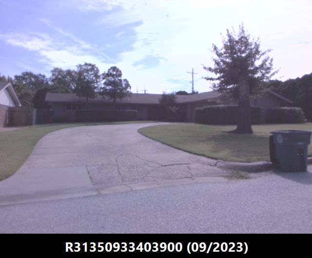
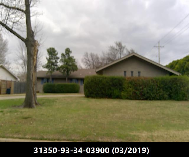
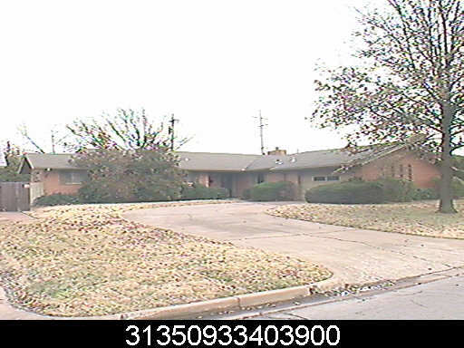
| Situs Address | 6021 S KINGSTON AV E TULSA 741357659 |
|---|---|
| Owner Name |
FOX, JASON L
|
| Owner Mailing Address | 6021 S KINGSTON AVE TULSA , OK 74135 |
| Account Type | Residential |
| Parcel ID | 31350-93-34-03900 |
| Land Area | 0.29 acres / 12,445 sq ft |
| School District | T-1A |
| Legal Description | Subdivision: PARK PLAZA (31350) Legal: LOT 15 BLK 16 Section: 34 Township: 19 Range: 13 |
| Zoning | View City of Tulsa Zoning Data |
Improvements
Improvements
Tax Year: 2025
| Tax Year | Yr Blt | Property Type | Livable | Stories | Story Height | Baths | Roof |
|---|---|---|---|---|---|---|---|
| Imp # | Use | Foundation | Exterior | HVAC Type | |||
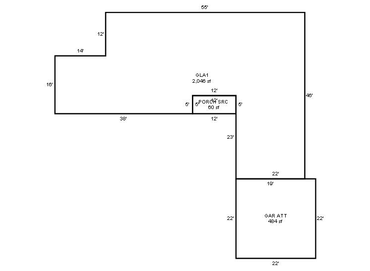
| 2025 | 1962 | Residential | 2,046 sqft | 1.00 | 8 | 2.10 | Composition Shingle |
| 1.00 | Ranch 1 Story | Slab | Frame Siding/Brick/Stone Veneer | Cool Air in Heat Ducts | |||
Tax Year: 2024
| Tax Year | Yr Blt | Property Type | Livable | Stories | Story Height | Baths | Roof |
|---|---|---|---|---|---|---|---|
| Imp # | Use | Foundation | Exterior | HVAC Type | |||
| 2024 | 1962 | Residential | 2,046 sqft | 1.00 | 8 | 2.10 | Composition Shingle |
| 1.00 | Ranch 1 Story | Slab | Frame Siding/Brick/Stone Veneer | Cool Air in Heat Ducts | |||
Tax Year: 2023
| Tax Year | Yr Blt | Property Type | Livable | Stories | Story Height | Baths | Roof |
|---|---|---|---|---|---|---|---|
| Imp # | Use | Foundation | Exterior | HVAC Type | |||
| 2023 | 1962 | Residential | 2,046 sqft | 1.00 | 8 | 2.10 | Composition Shingle |
| 1.00 | Ranch 1 Story | Slab | Frame Siding/Brick/Stone Veneer | Cool Air in Heat Ducts | |||
Values and Tax Information
| 2023 | 2024 | 2025 | |
|---|---|---|---|
| Fair Cash(Market) Value | $250,147 | $227,775 | $285,500 |
| Total Taxable Value (Capped) | $203,963 | $214,162 | $224,870 |
| Improvement Value | $222,886 | $200,514 | $258,239 |
| Land Value | $27,261 | $27,261 | $27,261 |
| Assessment Ratio | 11% | 11% | 11% |
| Gross Assessed Value | $22,436 | $23,558 | $24,736 |
| Exemptions | $0 | $0 | $0 |
| Net Assessed Value | $22,436 | $23,558 | $24,736 |
| School District | T-1A | ||
| Tax Rate | 126.91 | 129.51 | 129.51 |
| Estimated taxes | $2,847 | $3,051 | $3,204 |
| Last Notice Date | 1/28/2025 | ||
Exemptions Claimed
| 2023 | 2024 | 2025 | |
|---|---|---|---|
| Homestead | - | - | Apply |
| Additional Homestead | - | - | - |
| Senior Valuation Limitation | - | - | - |
| 100% Disabled Veteran | - | - | - |
Sales/Documents
| Sale Date | Grantor | Grantee | Sale Price | Deed Type | Document Number |
|---|---|---|---|---|---|
| 5/3/2022 | FOX, JASON L & BRANDI | FOX, JASON L | $0 | Quit Claim Deed | 2022049410 |
| 3/11/2016 | HILL, DARREN W & KAREN A | FOX, JASON L & BRANDI | $185,000 | General Warranty Deed | 2016026584 |
| 7/23/2015 | JACOBSON, RUSSELL MAYNARD JR | HILL, DARREN W & KAREN A | $112,500 | General Warranty Deed | 2015067562 |
| 10/14/2011 | JACOBSON, RUSSELL M | JACOBSON, RUBY | $0 | Affidavit Of Surviving Joint Tenant | 2011089919 |
| 8/31/2011 | JACOBSON, RUBY ESTATE OF | JACOBSON, RUSSELL MAYNARD JR | $0 | Decree Of Distribution | 2011087821 |
Sales/Documents
| Sale Date | 5/3/2022 |
|---|---|
| Grantor | FOX, JASON L & BRANDI |
| Grantee | FOX, JASON L |
| Sale Price | $0 |
| Deed Type | Quit Claim Deed |
| Document Number | 2022049410 |
| Sale Date | 3/11/2016 |
| Grantor | HILL, DARREN W & KAREN A |
| Grantee | FOX, JASON L & BRANDI |
| Sale Price | $185,000 |
| Deed Type | General Warranty Deed |
| Document Number | 2016026584 |
| Sale Date | 7/23/2015 |
| Grantor | JACOBSON, RUSSELL MAYNARD JR |
| Grantee | HILL, DARREN W & KAREN A |
| Sale Price | $112,500 |
| Deed Type | General Warranty Deed |
| Document Number | 2015067562 |
| Sale Date | 10/14/2011 |
| Grantor | JACOBSON, RUSSELL M |
| Grantee | JACOBSON, RUBY |
| Sale Price | $0 |
| Deed Type | Affidavit Of Surviving Joint Tenant |
| Document Number | 2011089919 |
| Sale Date | 8/31/2011 |
| Grantor | JACOBSON, RUBY ESTATE OF |
| Grantee | JACOBSON, RUSSELL MAYNARD JR |
| Sale Price | $0 |
| Deed Type | Decree Of Distribution |
| Document Number | 2011087821 |
Images
Sketches