General Information
| Situs Address | 609 W 36 ST S SAND SPRINGS 74063 |
|---|---|
| Owner Name |
MCFARLIN, DAREN & ASHLEY NICOLE COOPER
|
| Owner Mailing Address | 609 W 36TH ST SAND SPRINGS , OK 740632843 |
| Account Type | Residential |
| Parcel ID | 62243-91-22-46160 |
| Land Area | 0.24 acres / 10,530 sq ft |
| School District | SS-2A |
| Legal Description | Subdivision: PRATTWOOD ESTATES IV L1-10 B3 & L1-4 B4 (62243) Legal: LT 3 BLK 3 Section: 22 Township: 19 Range: 11 |
| Zoning | View INCOG's Zoning Data |
Improvements
Improvements
Tax Year: 2025
| Tax Year | Yr Blt | Property Type | Livable | Stories | Story Height | Baths | Roof |
|---|---|---|---|---|---|---|---|
| Imp # | Use | Foundation | Exterior | HVAC Type | |||
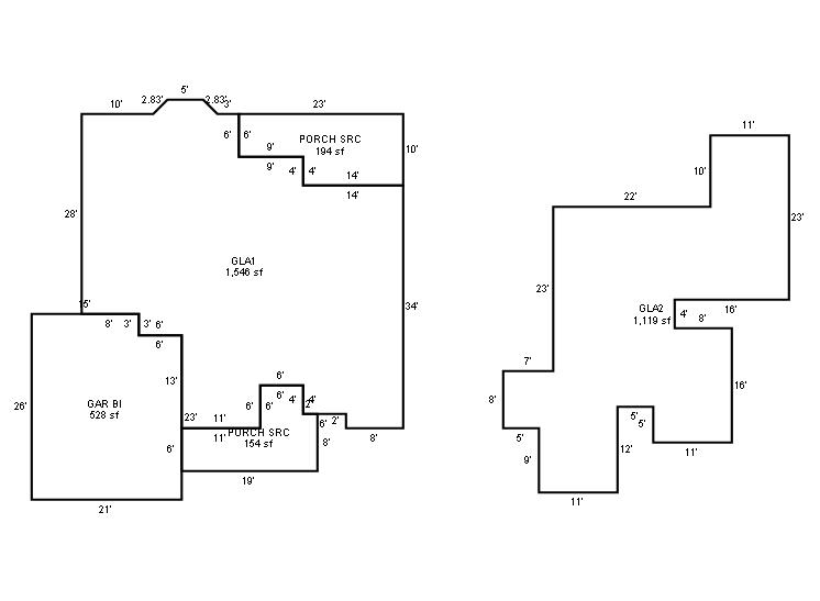
| 2025 | 1994 | Residential | 2,665 sqft | 1.75 | 8 | 2.10 | Composition Shingle |
| 1.00 | 1½ Story Fin | Slab | Frame Siding/Brick/Stone Veneer | Cool Air in Heat Ducts | |||
Tax Year: 2024
| Tax Year | Yr Blt | Property Type | Livable | Stories | Story Height | Baths | Roof |
|---|---|---|---|---|---|---|---|
| Imp # | Use | Foundation | Exterior | HVAC Type | |||
| 2024 | 1994 | Residential | 2,665 sqft | 1.75 | 8 | 2.10 | Composition Shingle |
| 1.00 | 1½ Story Fin | Slab | Frame Siding/Brick/Stone Veneer | Cool Air in Heat Ducts | |||
Tax Year: 2023
| Tax Year | Yr Blt | Property Type | Livable | Stories | Story Height | Baths | Roof |
|---|---|---|---|---|---|---|---|
| Imp # | Use | Foundation | Exterior | HVAC Type | |||
| 2023 | 1994 | Residential | 2,665 sqft | 1.75 | 8 | 2.10 | Composition Shingle |
| 1.00 | 1½ Story Fin | Slab | Frame Siding/Brick/Stone Veneer | Cool Air in Heat Ducts | |||
Values and Tax Information
| 2023 | 2024 | 2025 | |
|---|---|---|---|
| Fair Cash(Market) Value | $295,200 | $337,500 | $299,500 |
| Total Taxable Value (Capped) | $258,301 | $337,500 | $299,500 |
| Improvement Value | $268,700 | $311,000 | $273,000 |
| Land Value | $26,500 | $26,500 | $26,500 |
| Assessment Ratio | 11% | 11% | 11% |
| Gross Assessed Value | $28,413 | $37,125 | $32,945 |
| Exemptions | $0 | $0 | $0 |
| Net Assessed Value | $28,413 | $37,125 | $32,945 |
| School District | SS-2A | ||
| Tax Rate | 126.21 | 127.61 | 127.61 |
| Estimated taxes | $3,586 | $4,738 | $4,204 |
| Last Notice Date | 3/26/2024 | ||
Exemptions Claimed
| 2023 | 2024 | 2025 | |
|---|---|---|---|
| Homestead | - | - | Apply |
| Additional Homestead | - | - | - |
| Senior Valuation Limitation | - | - | - |
| 100% Disabled Veteran | - | - | - |
Sales/Documents
| Sale Date | Grantor | Grantee | Sale Price | Deed Type | Document Number |
|---|---|---|---|---|---|
| 7/18/2023 | LITKE, BRADLEY J & LORINDA K | MCFARLIN, DAREN & ASHLEY NICOLE COOPER | $337,500 | General Warranty Deed | 2023059617 |
| 4/10/2018 | LITKE, BRADLEY J | LITKE, BRADLEY J & LORINDA K | $0 | Deed | 2018034347 |
| 7/27/2017 | HUD, C/O INFORMATION SYSTEMS NETWORK | LITKE, BRADLEY J | $0 | Special Warranty Deed | 2017073755 |
| 12/7/2016 | PENNYMAC LOAN SERVICES LLC | HUD, C/O INFORMATION SYSTEMS NETWORK | $0 | General Warranty Deed | 2017024181 |
| 10/13/2016 | TULSA COUNTY SHERIFF | PENNYMAC LOAN SERVICES LLC | $0 | Sheriff's Deed | 2016103753 |
| 8/18/2008 | TURNEY, JACK W AND KRISTA K | TURNEY, BRANDON L & CHRISTY | $235,000 | General Warranty Deed | 2008087456 |
| 12/1/1995 | $170,000 | Warranty Deed | 2000182414 BK-05768PG-01141 | ||
| 9/1/1993 | $183,000 | History | 2000182415 BK-05545PG-00560 |
Sales/Documents
| Sale Date | 7/18/2023 |
|---|---|
| Grantor | LITKE, BRADLEY J & LORINDA K |
| Grantee | MCFARLIN, DAREN & ASHLEY NICOLE COOPER |
| Sale Price | $337,500 |
| Deed Type | General Warranty Deed |
| Document Number | 2023059617 |
| Sale Date | 4/10/2018 |
| Grantor | LITKE, BRADLEY J |
| Grantee | LITKE, BRADLEY J & LORINDA K |
| Sale Price | $0 |
| Deed Type | Deed |
| Document Number | 2018034347 |
| Sale Date | 7/27/2017 |
| Grantor | HUD, C/O INFORMATION SYSTEMS NETWORK |
| Grantee | LITKE, BRADLEY J |
| Sale Price | $0 |
| Deed Type | Special Warranty Deed |
| Document Number | 2017073755 |
| Sale Date | 12/7/2016 |
| Grantor | PENNYMAC LOAN SERVICES LLC |
| Grantee | HUD, C/O INFORMATION SYSTEMS NETWORK |
| Sale Price | $0 |
| Deed Type | General Warranty Deed |
| Document Number | 2017024181 |
| Sale Date | 10/13/2016 |
| Grantor | TULSA COUNTY SHERIFF |
| Grantee | PENNYMAC LOAN SERVICES LLC |
| Sale Price | $0 |
| Deed Type | Sheriff's Deed |
| Document Number | 2016103753 |
| Sale Date | 8/18/2008 |
| Grantor | TURNEY, JACK W AND KRISTA K |
| Grantee | TURNEY, BRANDON L & CHRISTY |
| Sale Price | $235,000 |
| Deed Type | General Warranty Deed |
| Document Number | 2008087456 |
| Sale Date | 12/1/1995 |
| Grantor | |
| Grantee | |
| Sale Price | $170,000 |
| Deed Type | Warranty Deed |
| Document Number | 2000182414 BK-05768PG-01141 |
| Sale Date | 9/1/1993 |
| Grantor | |
| Grantee | |
| Sale Price | $183,000 |
| Deed Type | History |
| Document Number | 2000182415 BK-05545PG-00560 |
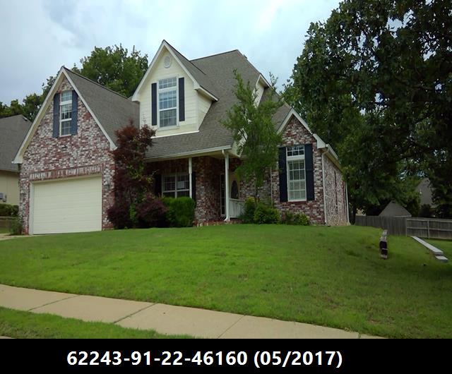
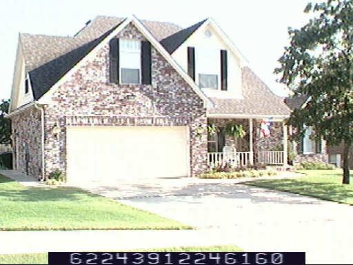
Images
Sketches