General Information
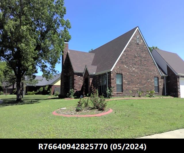
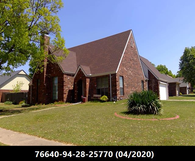
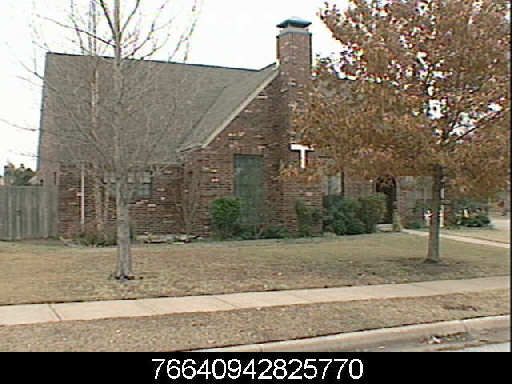
| Situs Address | 4525 S 134 AV E TULSA 74134 |
|---|---|
| Owner Name |
M&M CAPITAL INVESTMENTS LLC
|
| Owner Mailing Address | PO BOX 902 BROKEN ARROW , OK 740130902 |
| Account Type | Residential |
| Parcel ID | 76640-94-28-25770 |
| Land Area | 0.30 acres / 13,287 sq ft |
| School District | T-9A |
| Legal Description | Subdivision: QUAIL RIDGE (76640) Legal: LT 4 BLK 5 Section: 28 Township: 19 Range: 14 |
| Zoning | View City of Tulsa Zoning Data |
Improvements
Improvements
Tax Year: 2025
| Tax Year | Yr Blt | Property Type | Livable | Stories | Story Height | Baths | Roof |
|---|---|---|---|---|---|---|---|
| Imp # | Use | Foundation | Exterior | HVAC Type | |||
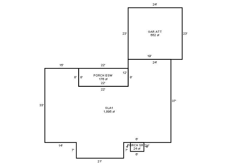
| 2025 | 1986 | Residential | 1,895 sqft | 1.00 | 8 | 2.00 | Composition Shingle |
| 1.00 | Ranch 1 Story | Slab | Frame Siding/Brick/Stone Veneer | Cool Air in Heat Ducts | |||
Tax Year: 2024
| Tax Year | Yr Blt | Property Type | Livable | Stories | Story Height | Baths | Roof |
|---|---|---|---|---|---|---|---|
| Imp # | Use | Foundation | Exterior | HVAC Type | |||
| 2024 | 1986 | Residential | 1,895 sqft | 1.00 | 8 | 2.00 | Composition Shingle |
| 1.00 | Ranch 1 Story | Slab | Frame Siding/Brick/Stone Veneer | Cool Air in Heat Ducts | |||
Tax Year: 2023
| Tax Year | Yr Blt | Property Type | Livable | Stories | Story Height | Baths | Roof |
|---|---|---|---|---|---|---|---|
| Imp # | Use | Foundation | Exterior | HVAC Type | |||
| 2023 | 1986 | Residential | 1,895 sqft | 1.00 | 8 | 2.00 | Composition Shingle |
| 1.00 | Ranch 1 Story | Slab | Frame Siding/Brick/Stone Veneer | Cool Air in Heat Ducts | |||
Values and Tax Information
| 2023 | 2024 | 2025 | |
|---|---|---|---|
| Fair Cash(Market) Value | $251,408 | $252,302 | $292,600 |
| Total Taxable Value (Capped) | $166,950 | $175,297 | $184,062 |
| Improvement Value | $222,701 | $223,595 | $263,893 |
| Land Value | $28,707 | $28,707 | $28,707 |
| Assessment Ratio | 11% | 11% | 11% |
| Gross Assessed Value | $18,365 | $19,283 | $20,246 |
| Exemptions | $0 | $0 | $0 |
| Net Assessed Value | $18,365 | $19,283 | $20,246 |
| School District | T-9A | ||
| Tax Rate | 127.87 | 131.23 | 131.23 |
| Estimated taxes | $2,348 | $2,531 | $2,657 |
| Last Notice Date | 1/28/2025 | ||
Exemptions Claimed
| 2023 | 2024 | 2025 | |
|---|---|---|---|
| Homestead | - | - | Apply |
| Additional Homestead | - | - | - |
| Senior Valuation Limitation | - | - | - |
| 100% Disabled Veteran | - | - | - |
Sales/Documents
| Sale Date | Grantor | Grantee | Sale Price | Deed Type | Document Number |
|---|---|---|---|---|---|
| 8/26/2020 | STONE, LOYE E & CAROLYN S TTEE, LOYE E & CAROLYN S STONE REV TRUST | M&M CAPITAL INVESTMENTS LLC | $159,000 | Warranty Deed | 2020085809 |
| 3/13/2009 | STONE, LOYE E | STONE, LOYE E & CAROLYN S TTEE LOYE E & CAROLYN S STONE REV TRUST | $0 | Quit Claim Deed | 2009022971 |
| 10/1/2004 | FISCHER, CURTIS J | STONE, LOYE E | $135,000 | General Warranty Deed | 2004129882 |
| 11/1/1993 | $97,000 | History | 2000223139 BK-05567PG-01890 | ||
| 12/1/1992 | $93,000 | History | 2000223140 BK-05457PG-01693 |
Sales/Documents
| Sale Date | 8/26/2020 |
|---|---|
| Grantor | STONE, LOYE E & CAROLYN S TTEE, LOYE E & CAROLYN S STONE REV TRUST |
| Grantee | M&M CAPITAL INVESTMENTS LLC |
| Sale Price | $159,000 |
| Deed Type | Warranty Deed |
| Document Number | 2020085809 |
| Sale Date | 3/13/2009 |
| Grantor | STONE, LOYE E |
| Grantee | STONE, LOYE E & CAROLYN S TTEE LOYE E & CAROLYN S STONE REV TRUST |
| Sale Price | $0 |
| Deed Type | Quit Claim Deed |
| Document Number | 2009022971 |
| Sale Date | 10/1/2004 |
| Grantor | FISCHER, CURTIS J |
| Grantee | STONE, LOYE E |
| Sale Price | $135,000 |
| Deed Type | General Warranty Deed |
| Document Number | 2004129882 |
| Sale Date | 11/1/1993 |
| Grantor | |
| Grantee | |
| Sale Price | $97,000 |
| Deed Type | History |
| Document Number | 2000223139 BK-05567PG-01890 |
| Sale Date | 12/1/1992 |
| Grantor | |
| Grantee | |
| Sale Price | $93,000 |
| Deed Type | History |
| Document Number | 2000223140 BK-05457PG-01693 |
Images
Sketches