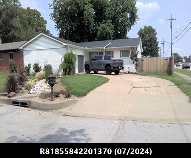
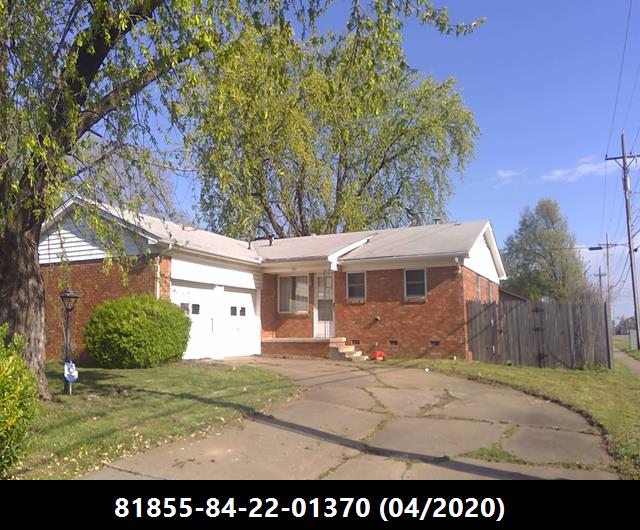
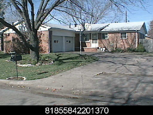
R81855842201370
700 W ATLANTA CT S BROKEN ARROW 740126905
$146,500
$16,115
General Information
| Situs Address | 700 W ATLANTA CT S BROKEN ARROW 740126905 |
|---|---|
| Owner Name |
ELLIS, PARKER R
|
| Owner Mailing Address | 700 W ATLANTA CT BROKEN ARROW , OK 740126905 |
| Account Type | Residential |
| Parcel ID | 81855-84-22-01370 |
| Land Area | 0.19 acres / 8,400 sq ft |
| School District | BA-3A |
| Legal Description | Subdivision: VILLAGE SQUARE (81855) Legal: LT 1 BLK 3 Section: 22 Township: 18 Range: 14 |
| Zoning | View INCOG's Zoning Data |
Improvements
Improvements
Tax Year: 2025
| Tax Year | Yr Blt | Property Type | Livable | Stories | Story Height | Baths | Roof |
|---|---|---|---|---|---|---|---|
| Imp # | Use | Foundation | Exterior | HVAC Type | |||
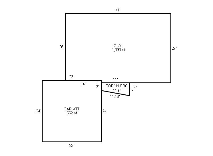
| 2025 | 1966 | Residential | 1,093 sqft | 1.00 | 8 | 1.00 | Composition Shingle |
| 1.00 | Ranch 1 Story | Crawl Space | Frame Siding/Brick/Stone Veneer | Cool Air in Heat Ducts | |||
Tax Year: 2024
| Tax Year | Yr Blt | Property Type | Livable | Stories | Story Height | Baths | Roof |
|---|---|---|---|---|---|---|---|
| Imp # | Use | Foundation | Exterior | HVAC Type | |||
| 2024 | 1966 | Residential | 1,093 sqft | 1.00 | 8 | 1.00 | Composition Shingle |
| 1.00 | Ranch 1 Story | Crawl Space | Frame Masonry Veneer | Cool Air in Heat Ducts | |||
Tax Year: 2023
| Tax Year | Yr Blt | Property Type | Livable | Stories | Story Height | Baths | Roof |
|---|---|---|---|---|---|---|---|
| Imp # | Use | Foundation | Exterior | HVAC Type | |||
| 2023 | 1966 | Residential | 1,093 sqft | 1.00 | 8 | 1.00 | Composition Shingle |
| 1.00 | Ranch 1 Story | Crawl Space | Frame Masonry Veneer | Cool Air in Heat Ducts | |||
Values and Tax Information
| 2023 | 2024 | 2025 | |
|---|---|---|---|
| Fair Cash(Market) Value | $157,233 | $152,737 | $146,500 |
| Total Taxable Value (Capped) | $157,233 | $152,737 | $146,500 |
| Improvement Value | $138,153 | $133,657 | $127,420 |
| Land Value | $19,080 | $19,080 | $19,080 |
| Assessment Ratio | 11% | 11% | 11% |
| Gross Assessed Value | $17,296 | $16,801 | $16,115 |
| Exemptions | -$1,000 | -$1,000 | $0 |
| Net Assessed Value | $16,296 | $15,801 | $16,115 |
| School District | BA-3A | ||
| Tax Rate | 128.50 | 128.81 | 128.81 |
| Estimated taxes | $2,094 | $2,035 | $2,076 |
| Last Notice Date | 3/25/2025 | ||
Exemptions Claimed
| 2023 | 2024 | 2025 | |
|---|---|---|---|
| Homestead | Apply | ||
| Additional Homestead | - | - | - |
| Senior Valuation Limitation | - | - | - |
| 100% Disabled Veteran | - | - | - |
Sales/Documents
| Sale Date | Grantor | Grantee | Sale Price | Deed Type | Document Number |
|---|---|---|---|---|---|
| 11/8/2024 | MAYO, NATHAN & SUSIE | ELLIS, PARKER R | $199,000 | Warranty Deed | 2024097153 |
| 5/27/2022 | MYRIAD PROPERTIES LLC | MAYO, NATHAN & SUSIE | $189,000 | Warranty Deed | 2022060280 |
| 3/29/2021 | AMERICAN ADVISORS GROUP | MYRIAD PROPERTIES LLC | $100,500 | Special Warranty Deed | 2021040693 |
| 1/13/2021 | TULSA COUNTY SHERIFF | AMERICAN ADVISORS GROUP | $0 | Sheriff's Deed | 2021005695 |
| 8/14/2013 | SULLIVAN, ROBERT O | SULLIVAN, ROBERT OSBIN REV TRUST | $0 | Quit Claim Deed | 2013083255 |
| 7/26/2013 | SULLIVAN, ROBERT OSBIN REV TRUST | SULLIVAN, ROBERT O | $0 | Quit Claim Deed | 2013079054 |
| 6/14/2006 | SULLIVAN, ROBERT O | SULLIVAN, ROBERT OSBIN, TRUST | $0 | Quit Claim Deed | 2006067305 |
Sales/Documents
| Sale Date | 11/8/2024 |
|---|---|
| Grantor | MAYO, NATHAN & SUSIE |
| Grantee | ELLIS, PARKER R |
| Sale Price | $199,000 |
| Deed Type | Warranty Deed |
| Document Number | 2024097153 |
| Sale Date | 5/27/2022 |
| Grantor | MYRIAD PROPERTIES LLC |
| Grantee | MAYO, NATHAN & SUSIE |
| Sale Price | $189,000 |
| Deed Type | Warranty Deed |
| Document Number | 2022060280 |
| Sale Date | 3/29/2021 |
| Grantor | AMERICAN ADVISORS GROUP |
| Grantee | MYRIAD PROPERTIES LLC |
| Sale Price | $100,500 |
| Deed Type | Special Warranty Deed |
| Document Number | 2021040693 |
| Sale Date | 1/13/2021 |
| Grantor | TULSA COUNTY SHERIFF |
| Grantee | AMERICAN ADVISORS GROUP |
| Sale Price | $0 |
| Deed Type | Sheriff's Deed |
| Document Number | 2021005695 |
| Sale Date | 8/14/2013 |
| Grantor | SULLIVAN, ROBERT O |
| Grantee | SULLIVAN, ROBERT OSBIN REV TRUST |
| Sale Price | $0 |
| Deed Type | Quit Claim Deed |
| Document Number | 2013083255 |
| Sale Date | 7/26/2013 |
| Grantor | SULLIVAN, ROBERT OSBIN REV TRUST |
| Grantee | SULLIVAN, ROBERT O |
| Sale Price | $0 |
| Deed Type | Quit Claim Deed |
| Document Number | 2013079054 |
| Sale Date | 6/14/2006 |
| Grantor | SULLIVAN, ROBERT O |
| Grantee | SULLIVAN, ROBERT OSBIN, TRUST |
| Sale Price | $0 |
| Deed Type | Quit Claim Deed |
| Document Number | 2006067305 |
Images
Sketches