R83682840830580
208 S REDWOOD PL W BROKEN ARROW 740124530
$426,014
$45,862
General Information
| Situs Address | 208 S REDWOOD PL W BROKEN ARROW 740124530 |
|---|---|
| Owner Name |
MANNING, JODY MICHAEL
|
| Owner Mailing Address | 208 S REDWOOD PL BROKEN ARROW , OK 740124530 |
| Account Type | Residential |
| Parcel ID | 83682-84-08-30580 |
| Land Area | 0.48 acres / 20,809 sq ft |
| School District | BA-9A |
| Legal Description | Subdivision: MILLICENT RIDGE (83682) Legal: LT 1 BLK 2 Section: 08 Township: 18 Range: 14 |
| Zoning | View INCOG's Zoning Data |
Improvements
Improvements
Tax Year: 2025
| Tax Year | Yr Blt | Property Type | Livable | Stories | Story Height | Baths | Roof |
|---|---|---|---|---|---|---|---|
| Imp # | Use | Foundation | Exterior | HVAC Type | |||
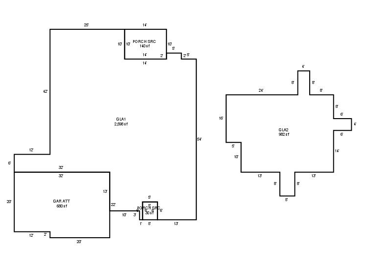
| 2025 | 1999 | Residential | 3,580 sqft | 1.50 | 8 | 3.10 | Composition Shingle |
| 1.00 | 1½ Story Fin | Slab | Frame Siding/Brick/Stone Veneer | Cool Air in Heat Ducts | |||
Tax Year: 2024
| Tax Year | Yr Blt | Property Type | Livable | Stories | Story Height | Baths | Roof |
|---|---|---|---|---|---|---|---|
| Imp # | Use | Foundation | Exterior | HVAC Type | |||
| 2024 | 1999 | Residential | 3,580 sqft | 1.50 | 8 | 3.10 | Composition Shingle |
| 1.00 | 1½ Story Fin | Slab | Frame Siding/Brick/Stone Veneer | Cool Air in Heat Ducts | |||
Tax Year: 2023
| Tax Year | Yr Blt | Property Type | Livable | Stories | Story Height | Baths | Roof |
|---|---|---|---|---|---|---|---|
| Imp # | Use | Foundation | Exterior | HVAC Type | |||
| 2023 | 1999 | Residential | 3,580 sqft | 1.50 | 8 | 3.10 | Composition Shingle |
| 1.00 | 1½ Story Fin | Slab | Frame Siding/Brick/Stone Veneer | Cool Air in Heat Ducts | |||
Values and Tax Information
| 2023 | 2024 | 2025 | |
|---|---|---|---|
| Fair Cash(Market) Value | $436,988 | $426,014 | - |
| Total Taxable Value (Capped) | $316,968 | $426,014 | - |
| Improvement Value | $385,688 | $374,714 | - |
| Land Value | $51,300 | $51,300 | - |
| Assessment Ratio | 11% | 11% | 11% |
| Gross Assessed Value | $34,866 | $46,862 | - |
| Exemptions | $0 | -$1,000 | -$1,000 |
| Net Assessed Value | $34,866 | $45,862 | - |
| School District | BA-9A | ||
| Tax Rate | 129.06 | 129.86 | 129.86 |
| Estimated taxes | $4,500 | $5,956 | - |
| Last Notice Date | 1/30/2024 | ||
Exemptions Claimed
| 2023 | 2024 | 2025 | |
|---|---|---|---|
| Homestead | - | ||
| Additional Homestead | - | - | - |
| Senior Valuation Limitation | - | - | - |
| 100% Disabled Veteran | - | - | - |
Sales/Documents
| Sale Date | Grantor | Grantee | Sale Price | Deed Type | Document Number |
|---|---|---|---|---|---|
| 8/22/2023 | POWELL, CADE N AND WHITNEY B | MANNING, JODY MICHAEL | $429,000 | Warranty Deed | 2023071280 |
| 1/28/2019 | ASHMORE, SCOTT P AND LYNN | POWELL, CADE N AND WHITNEY B | $287,500 | General Warranty Deed | 2019009815 |
| 6/11/2012 | ASHMORE, SCOTT P | ASHMORE, SCOTT P AND LYNN | $0 | Warranty Deed | 2012058562 |
| 4/1/2000 | $259,000 | General Warranty Deed | 2000274598 BK-06354PG-02373 | ||
| 10/1/1998 | $228,500 | History | 2000274599 BK-06123PG-01966 |
Sales/Documents
| Sale Date | 8/22/2023 |
|---|---|
| Grantor | POWELL, CADE N AND WHITNEY B |
| Grantee | MANNING, JODY MICHAEL |
| Sale Price | $429,000 |
| Deed Type | Warranty Deed |
| Document Number | 2023071280 |
| Sale Date | 1/28/2019 |
| Grantor | ASHMORE, SCOTT P AND LYNN |
| Grantee | POWELL, CADE N AND WHITNEY B |
| Sale Price | $287,500 |
| Deed Type | General Warranty Deed |
| Document Number | 2019009815 |
| Sale Date | 6/11/2012 |
| Grantor | ASHMORE, SCOTT P |
| Grantee | ASHMORE, SCOTT P AND LYNN |
| Sale Price | $0 |
| Deed Type | Warranty Deed |
| Document Number | 2012058562 |
| Sale Date | 4/1/2000 |
| Grantor | |
| Grantee | |
| Sale Price | $259,000 |
| Deed Type | General Warranty Deed |
| Document Number | 2000274598 BK-06354PG-02373 |
| Sale Date | 10/1/1998 |
| Grantor | |
| Grantee | |
| Sale Price | $228,500 |
| Deed Type | History |
| Document Number | 2000274599 BK-06123PG-01966 |
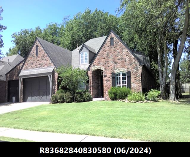
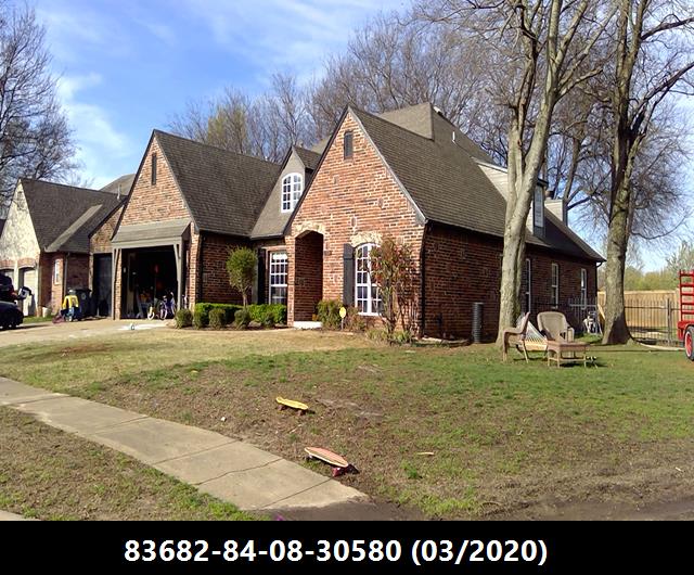
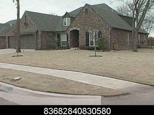
Images
Sketches